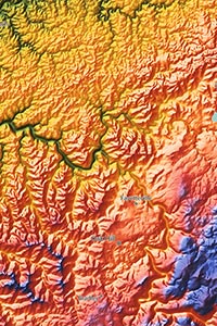
Note: Minimal text labels are included in order to preserve the artistic style of West Virginia's terrain.

Green represents West Virginia's relatively low elevation areas. This includes two major regions: the western lands near the Ohio River, and the eastern tip near the borders of Maryland and Virginia. Many of West Virginia's most populated cities lie in the western low region, including Charleston, Huntington, Parkersburg, and Wheeling.
Mid-level elevation is shown with warm colors like yellow, orange, and red. This includes much of the land in central West Virginia either at the base of mountains or in the valleys between them. Morgantown lies in this mid-level elevation range.
High elevation is shown with blue and purple, and the highest mountains are shown with the color white. The Allegheny Mountains and Cumberland Plateau form West Virginia's highest lands. Spruce Knob is the highest point in West Virginia, with a peak elevation of 4,862 ft / 1482 m.
Learn how this West Virginia topographic image was created with digital elevation data.
Nestled in the heart of Appalachia, nearly the entire state of West Virginia is rugged and mountainous, and that mountainous landscape is clearly shown in the map. The most prominent mountains lie in the Allegheny Mountains in central and eastern West Virginia. The Cumberland Mountains, Cumberland Plateau, Allegheny Plateau, and Shenandoah Mountain are all visible in the map.
West Virginia's lakes and reservoirs are also shown, including Tygart Lake, Sutton Lake, Summersville Lake, Mount Storm Lake, Bluestone Lake, and others.
River valleys can also be seen, especially the Kanawha River valley.
77 West Virginia cities and towns are labeled on the map.
Major cities like Charleston, Huntington, Parkersburg, Morgantown, Wheeling, Fairmont, and Teays Valley are all shown.
Some of the medium and smaller towns on the map include Martinsburg, Elkins, Keyser, Grafton, Lewisburg, Williamson, Kingwood, Hinton, Welch, Vienna, Bridgeport, Oak Hill, Hurricane, Sissonville, Ravenswood, Pinch, Blennerhassett, Follansbee, Crab Orchard, Chester, Craigsville, Mannington, as well as many others.

More than a map, this West Virginia physical map is a work of art. The vibrant colors, bold shading of mountains, and distinct modern style make this map one of the most visually attractive maps you've likely ever seen.
When displayed on your wall, this map is guaranteed to attract attention and inspire interest and curiosity in the beautiful West Virginia landscape. It's also sure to spice up the decor of any room, whether in your office, home, business, classroom, or anywhere else to celebrate the natural beauty of West Virginia.